The Flinders Ranges is one of the best places to go hiking in South Australia. The scenery is rugged, the wildlife is everywhere, and there are tracks to suit all fitness levels.
Over the years, I’ve been lucky to visit many times, often to catch up with my parents who live in the region. I’ve used those trips as a chance to explore some of the great walking trails, and in this post, I want to share some of my favourites.
I’ll take you through hikes I’ve done at Wilpena Pound, Alligator Gorge and Warren Gorge, and also talk about the Heysen Trail, which passes through the Flinders Ranges.
At the end, I’ll list some other walks to check out if you’re planning a visit and share my best tips.
But first, why should you go hiking in the Flinders Ranges?
Have Questions? – Come and join the Facebook Group and ask any questions you may have about travel in South Australia. We can provide answers, make further suggestions and update you with the latest information. Click here to join now.
TL;DR? Here's the outline

Why Hike in the Flinders Ranges?
The Flinders Ranges has some of the most interesting landscapes in South Australia. The area is full of deep gorges, rocky ridges and wide open views, and the colours change throughout the day.
It’s a great place to get out into nature, with plenty of walking trails to explore. You’ll often see kangaroos, emus, lizards and birds while you’re hiking, and if you’re lucky, you might spot a yellow-footed rock wallaby.
The area also has a long Aboriginal and European history, which you can learn about along the way. Most hikes are well marked, and there are short walks, full-day hikes and even multi-day treks to choose from.
Whether you’re just after a short stroll or a bit more of a challenge, the Flinders Ranges hikes have something for everyone.
The Top Three Areas to Hike
There are walking trails all through the Flinders Ranges, but some places stand out more than others.
These are the three areas I keep going back to, with great hikes, easy access, and plenty to see along the way.

Wilpena Pound
Wilpena Pound is one of the most popular hiking areas in the Flinders Ranges, and for good reason.
The natural amphitheatre is surrounded by rugged peaks, with walking trails leading to lookouts, gorges and even up to the highest point, St Mary Peak.
There are hikes for all levels – from short walks like the Hills Homestead and Wangara Lookout to full-day treks to St Mary Peak or around the Pound.
Most trails start from the Wilpena Pound Resort, where you’ll also find maps and information.


I’ve personally done most of the short walks, some multiple times.
Hiking into the Pound never gets old, especially if making the final trek up to the Wangara Lookout where you get a good view of the flat centre and the surrounding hills.
If also done the longer, but mostly flat, Bridle Gap Hike, which crosses the floor of the pound and climbs up the rim on the other side, giving great views of the ranges beyond.
Alligator Gorge
Alligator Gorge is found in Mount Remarkable National Park, near Wilmington in the southern Flinders Ranges.
It’s known for its steep, narrow rock walls and layered red cliffs. The trail takes you through The Narrows and past the Terraces – both are great spots for photos.
It’s a short but steep walk down into the gorge from the car park, with lots of steps, so be prepared for a bit of a workout on the way back up. The track can be a bit uneven in places, but it’s worth it for the views.


During my visits I’ve done the large loop hike through the gorge up the sides, around, and back down into the gorge – before climbing those steps up to the car park again!
Apart from the up and down parts, it’s not too difficult and we saw a lot of kangaroos and birds.
The best parts though are in the gorge, so the Terraces and Narrows, so if you don’t do the whole loop, you won’t miss too much if you do the shorter hikes.
Warren Gorge
Warren Gorge is a quieter spot near Quorn that’s great for a peaceful walk and spotting wildlife.
The main loop trail is an easy walk through the gorge, with rugged cliffs on either side. It’s one of the best places to see yellow-footed rock wallabies, especially in the early morning or late afternoon.


The track is well-marked and not too challenging, making it a good option for most walkers. I loved coming across a “Visitor’s Book” right at the top at the Smoke-Oh Lookout – which is a great place to enjoy the view.
If you don’t want to walk the whole trail, it’s lovely just to do the section in the gorge, through the huge river gums.
The Heysen Trail
The Heysen Trail is South Australia’s longest dedicated walking trail, stretching around 1,200 kilometres from Cape Jervis on the Fleurieu Peninsula all the way to Parachilna Gorge in the northern Flinders Ranges.
It takes around two months to walk the full trail, but many people just do shorter sections.
Some of the most scenic parts of the trail are found in the Flinders Ranges. The northern sections take you through rugged landscapes, past deep gorges and across open plains with views that go on forever.
The trail goes through places like Mount Remarkable National Park, Wilpena Pound, Bunyeroo and Brachina Gorges, and finishes near Parachilna Gorge.

These areas are filled with classic Flinders Ranges scenery – red rocks, big skies, and plenty of wildlife.
Even if you’re not doing a long-distance walk, you can still do day hikes along parts of the Heysen Trail – the Bridle Gap hike I did at Wilpena Pound, for example, is part of it.
There are plenty of access points in and around the national parks and towns, and the trail is clearly marked.
It’s a great way to experience some of the best the Flinders Ranges has to offer.
Other Great Hikes in the Flinders Ranges
If you have more time or want to explore beyond the main areas, here are some other hikes worth checking out:
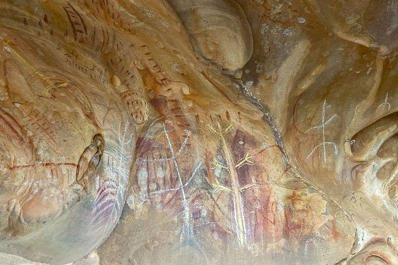
- Arkaroo Rock (Wilpena area) – 3 km return; a short walk to Aboriginal rock art and views towards Wilpena Pound.
- Bunyeroo Gorge Walk – 7 km return; follows a dry creek bed through a scenic gorge with interesting rock formations.
- Rawnsley Bluff Hike – 12.6 km return; a challenging hike with sweeping views over Wilpena Pound and the surrounding ranges.
- Mount Remarkable Summit Hike (from Melrose) – 12 km return; a steady climb to the summit with great views from the top.
- Dutchmans Stern Loop – 10.5 km circuit; offers a mix of landscapes and a lookout over the plains.
- Jarvis Hill Lookout (near Hawker) – Short walk or drive to a lookout with views over the town of Hawker and the surrounding hills; there’s also a loop walking track for a bit more of a stretch.


Tips for Hiking in the Flinders Ranges
Before you hit the trails, here are a few tips to help you stay safe, comfortable and respectful while hiking in the Flinders Ranges.
- Best time to go is from April to October, when the weather is cooler and better for walking. Summer can be extremely hot, with temperatures over 40°C, and many trails are closed and not safe to hike in that heat.
- Carry plenty of water – even short hikes can be hot and dry, and water isn’t always available on the trails.
- Wear sturdy shoes with good grip – tracks can be rocky, uneven and slippery after rain.
- Check trail conditions and weather forecasts before heading out. Some trails may be closed after heavy rain or during fire danger days.
- Start early in the day to avoid the heat and get the best light for photos.
- Watch for wildlife, especially in the early morning or late afternoon – kangaroos, emus and reptiles are common.
- Be mindful of cultural significance – for example, the Adnyamathanha people ask that visitors do not climb to the very top of St Mary Peak, as it is a sacred site. Always follow signage and respect local requests.

Before You Go
- Park entry fees apply in some areas, including Ikara–Flinders Ranges National Park and Mt Remarkable National Park. You can pay online through the National Parks SA website or at visitor centres.
- Camping and accommodation options range from bush camps to resorts like Wilpena Pound and Rawnsley Park, even Station Stays. Book ahead during school holidays or long weekends.
- Most trails are well-marked, but it’s still a good idea to carry a map or download one using an app like AllTrails. Visitor centres often have printed maps too.
- Phone reception is limited in many parts of the Flinders Ranges. If you’re heading out on a longer hike or walking alone, consider carrying a personal locator beacon (PLB) and always let someone know your plans.
The Flinders Ranges is a fantastic place to explore on foot, with hikes to suit every interest and fitness level. Whether you’re after a short walk, a scenic lookout, or a full-day adventure, there’s plenty to discover.
I’ve loved every visit and always find something new, and I hope this gives you a few ideas for your own trip.
